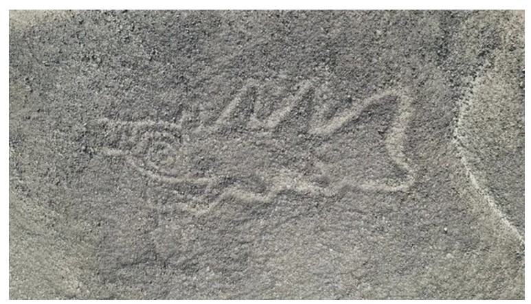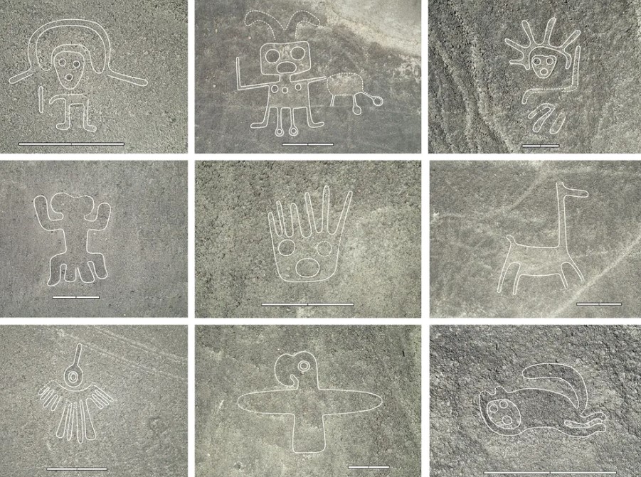
An A.I. assisted investigation has uncovered 303 previously unidentified geoglyphs in the Peruvian desert. Among these stunning artworks are unexpected designs, including orcas wielding knives. These are what are known as the Nazca lines, some of which are so huge they are best seen from air. Here’s their story:
What are the Nazca Lines?
The Nazca lines are a group of 700 lines or geoglyphs made in the soil of the Nazca Desert in southern Peru, between 500 BC and 500 AD. They were made by people who created shallow depresssions on the desert floor by removing pebbles and exposing different-coloured dirt. Created by the Nazca culture, a pre-Inca South American Indigenous group that thrived between roughly 200 B.C.E. and 600 C.E., living in coastal desert settlements along the Nazca River, they were developed in two major phases: the Paracas phase, from 400 to 200 BC, and the Nazca phase, from 200 BC to 500 AD. While archaeologists have also found painted ceramics linked the Nazca culture, they are mostly known for these enigmatic lines carved onto the desert ground.
Approximately 400 km (250 mi) south of Lima, Peru, is a high arid plateau that stretches more than 80 km (50 mi) between the towns of Nazca and Palpa and this is where the Nazca lines are found.
The top layer of the local reddish-brown ferric oxide-coated pebbles were removed to reveal the yellow-grey subsoil beneath. The shapes have been created using one continuous line. Typically, the figures are 10 to 15 cm (4-6 in) deep but their width varies considerably. More than half are a little more than 33 cm (13 in) wide, in some places they are only 30 cm (12 in) wide, while in others they are 1.8 m (6 ft) wide. The largest of the lines are 370 m (400 yd) long, although according to one estimate the largest geoglyphs are geometric shapes and patterns up to 30 miles long and the figures, which depict wild animals and plants, stretch to about 1,200 feet long. The combined length of all the lines is more than 1,300 km (800 mi), and the entire group covers an area of about 50 km2 (19 sq mi).
There is a variety of shapes, simple lines and zoomorphic designs, even including a human. While most of the lines run straight across the landscape, the more famous ones are the figurative designs of animals, such as monkeys, spiders, condors, and plants. Some of the lines form shapes that are best seen from around 500 m (1,600 ft) in the air. However, there are many that can be seen from the surrounding foothills and other high places. And because the areas is isolated and the climate is dry, windless and stable, the lines have been naturally preserved.
While, the Nazca lines were first mentioned in the 16th century by Europeans, they were first recorded by scientists in 1927 and over 430 were discovered the the next 100 years or so. They were designated as a UNESCO World Heritage Site in 1994. Although scientists disagree on their interpretation, most agree they had religious or spiritual significance to the people who created them.


New discoveries
More and more lines have been discovered with new technology, such as drones. And now artificial intelligence has been used to reveal hundreds more, carved into that same desert. These new, recently revealed lines, feature decapitated heads, llamas, orcas holding knives, and much more. The new A.I. assisted survey published in the Proceedings of the National Academy of Sciences has found 303 additional geoglyphs in just six months.

The researchers used the A.I. model to identify new, older, smaller and less obvious lines than the ones discovered previously, which it was able to do 20 times faster than humans. After it had revealed the figures, the team travelled to the area to confirm the findings.
Masato Saki lead author of the study said, “The traditional method of study, which consisted of visually identifying the geoglyphs from high-resolution images of this vast area, was slow and carried the risk of overlooking some of them.”

The 303 new geoglypic lines include depictions of human-like figures, livestock, fish, cats, birds, a ceremonial scene, people interacting with animals and killer whales wielding weapons, according to the study.
“On some pottery from the Nazca period, there are scenes depicting orcas with knives cutting off human heads,” Sakai tells New Scientist. “So we can position orcas as beings that carry out human sacrifice.”
The study team has said that they are going to continue the work and hope to identify an additional 250 more Nazca geoglyphs that have already been revealed by the A I model but which they were not able to verify in person.

“The A.I.-based analysis of remote sensing data is a major step forward, since a complete map of the geoglyphs of the Nazca region is still not available,” Karsten Lambers, an archaeologist at the Netherlands’ Leiden University who wasn’t involved in the study, tells New Scientist. However, “even this new, powerful technology is more likely to find the better visible geoglyphs—the low hanging fruits—than the more difficult ones that are likely still out there.”